(And El Paso, Too, But We Don’t Care About Them*)
Walk Score‘s oft-cited walkability index rates the pedestrian-friendliness of locations throughout the United States, Canada, Australia, and New Zealand, and even provides on its website easily-readable green-to-red heat maps for U. S. addresses. It gives Detroit a score of 50 out of 100, ranking our city at #22 in the 50 largest municipalities in the United States. Not bad, right?
Except, as cycling blog m-bike.org observes, Walk Score is broken.
One glance at the Walk Score website’s map view, and it is quite obvious that something has gone terribly wrong with the organization’s assessment of our city:
I agree that downtown could use a few things (like a bookstore and a place to buy broccoli) but with numerous major employers, almost-affordable housing, parks, shopping, the Rosa Parks Transit Center, and a nifty elevated monorail, it definitely warrants something more than the “car-dependent” red splash seen on the above map.
And why are the (supposedly) least walkable parts of town shaped like perfect right angles? Surely, it must be a math thing!
M-bike blames it all on the Detroit River. Walk Score’s algorithm, according to the blog, “might be okay for swimscore.com but it doesn’t work for walking.”
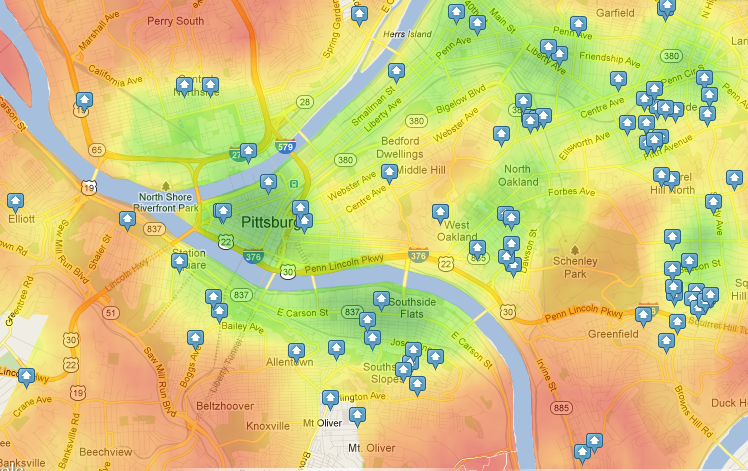
But water isn’t the real problem. See, for example, Pittsburgh. They have even more river than we do, and yet that city scores a 64. Still only “somewhat walkable,” but significantly higher a score than Detroit’s. And look, no funny red angles.
 Clearly, the river isn’t the problem: New York, San Francisco, Chicago, Miami — all of these places have more water than Detroit, and yet they place within the “very walkable” range, beating our city handily with scores ranging from 72 to 85.
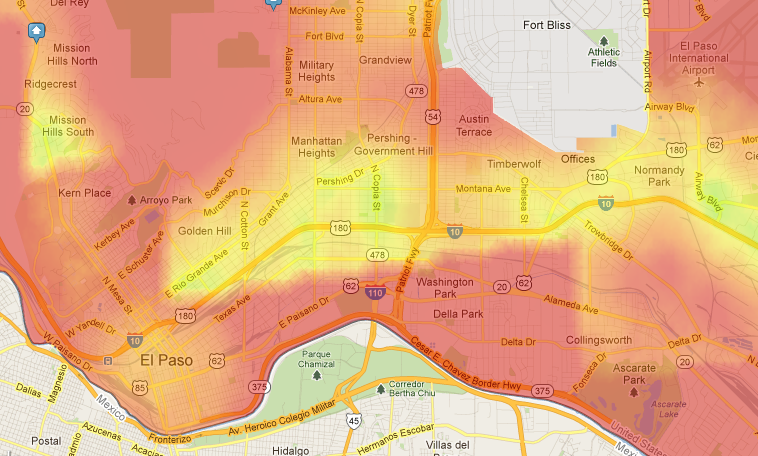
But there are two other cities (only two!) in the United States that generate a map with red angle-shapes like Detroit’s. One is El Paso:
 And the other is Buffalo, where the angle is the 180 degree kind, and cuts right through the middle of downtown:
 What do all three of these cities have in common? The problem, apparently, has nothing to do with water, as m-bike suggests, but instead with the fact that Walk Score is utterly confounded by international border cities!
(Which must, incidentally, make Stanstead, Quebec and Derby Line, Vermont’s Haskell Free Library the least walkable single building in the entire world).
Understandably, Walk Score staff denied my request to reveal their site’s secret walkability-calculating algorithm. However, in an email, customer service specialist Aleisha Jacobson concedes “there is a known bug that affects some addresses near international borders.”
This is a very bad thing. Since its inception in 2007, Walk Score has become much more than just a cartographic curiosity. According to the service’s own vision statement, Walk Score wants its walkability index to be displayed right up there next to “beds” and “baths” on every real estate listing in the world. Already, according to the site’s own estimations, “over 15,000 sites use Walk Score services.” A high Walk Score rating can add several thousand dollars to the value of a home, and it’s not too much of a stretch to imagine major employers using Walk Score to help determine where to locate a new office.
According to Ms. Jacobson, “we don’t have a time line for when this issue may be corrected.”
On behalf of the 1,624,208 residents of the “some addresses” that are being continually shafted by an inaccurate walkability index, I respectully request that Walk Score fix their algorithm, like, five years ago.
*Just kidding, we care about El Paso. We just don’t love it like we love Detroit.


I had the same conversation with Aleisha in July of last year. She acknowledged it was a border problem with U.S. and Canada. I just didn’t make it very clear in the m-bike article that it wasn’t about the river.
Matt from Walk Score here — thanks for the detailed post!
One of our primary data sources has a problem near international borders which leads to the red zig zags you see in our heatmap image. We’re doing two things about this (it’s not an easy fix because it’s the underlying data, not our algorithm). 1) We’re working with the data provider to try to have them fix it 2) We’re evaluating other data sources to use.
So although I don’t have a timeline on a fix — we’re actively working on it. The title of the post pains me — I was a Tiger’s fan as a kid (go Kirk GIbson!) and so we want to do right by Detroit!
Thank you for your response, Matt. I’m sure all my readers are happy to know you are working on it.
So when do we get a heat map for Derby Line? :)
Any evidence that the conditions for this algorithmic goof have improved in the 1.5 years since you reported on this? Whatever bug has afflicted Detroit, it seems to have afflicted Buffalo in the same capacity. Even more frustrating is that the algorithm no doubt engages with the heat map in ways that indicate percentage red/green/yellow, out of the overall total land area, meaning that the cities with smallest municipal limits are almost always going to win out over the bigger ones, since the are more likely to be fully urbanized than those cities that have demonstrated capacity to annex over the last 60 years. At 139 square miles, Detroit might not be a Jacksonville or Anchorage, but it’s certainly bigger than most other Midwestern cities, and virtually all Northeastern Cities as well, putting it at an intrinsic disadvantage, population loss notwithstanding. After all, every Detroiter who cares about this stuff knows that St. Louis has lost just as much population at the Motor City, but its much, much smaller city limits mean the denominator in any quotient is a lot lower, resulting in a higher percentage–and a higher Walk Score. (Of course, I’m assuming this without knowing what St. Louis’ walk score is, but it’s better than Detroit, right?!)
Walkscore is still giving “Detroit the Shaft” from what I can tell. “Actively working on it?” That sounds like good intentions based on the lack of results and lack of email response. If this were an NYC or Portland problem, it would have been fixed by now.